Documenting good practices in implementing GLTN Tools in Kenya
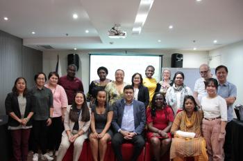
The Land and Natural Resources Tenure Learning Initiative for East and Southern Africa - TSLI-ESA , and Resource Conflict Institute - RECONCILE (an ILC member) jointly organized a four-day workshop in December 2017 to document the Good Practices in the Implementation of GLTN Land Tools in Kenya. Hosted by RECONCILE in Nakuru county, the workshop was attended by land and natural resources policy experts, and project implementing teams from RECONCILE, Pamoja Trust and UN-Habitat. The workshop was organized in partnership with the IFAD-supported Smallholder Dairy Commercialization Programme - SDCP, Upper Tana Natural Resources Management Project - UTaNRMP, Mwea Irrigation Scheme/National Irrigation Board, Mwea Irrigation Water Users Association, Technical University Kenya and Pamoja Trust.
Opening the workshop, TSLI-ESA Project Coordinator Mr. Solomon Mkumbwa noted that this was a key process in taking stock of TSLI-ESA experiences, impact and lessons learned as the regional project is winding up in Kenya. The project focus in Kenya was on participatory mapping and documentation of smallholder dairy farmers and their communally shared resources in three sub counties of Bomet County, geospatial enumeration of smallholder rice outgrowers' paddies in the Ndekia rice outgrower blocks in Kirinyaga county, and innovative applications of geospatial technologies and to strengthen monitoring and evaluation in IFAD-supported projects in the country.![]() The four day process that began on the 23rd of December 2017 provided an opportunity for partners and key resource persons to have reflections on the implementation process, share experiences, key lessons, and results to inform and guide future interventions that would apply the STDM tool in securing land and natural resource rights in IFAD-supported projects. The outcome of the process is a draft publication on Good Practices in the Implementation of GLTN Land Tools in Kenya, which will be published later in 2018.
The four day process that began on the 23rd of December 2017 provided an opportunity for partners and key resource persons to have reflections on the implementation process, share experiences, key lessons, and results to inform and guide future interventions that would apply the STDM tool in securing land and natural resource rights in IFAD-supported projects. The outcome of the process is a draft publication on Good Practices in the Implementation of GLTN Land Tools in Kenya, which will be published later in 2018.
TSLI-ESA II Project Achievements in Kenya
In Bomet County, participatory enumerations and geospatial mapping within Dairy Centralization Areas 1, 2 and 3 under the Scaling Up Participatory Enumeration and Mapping using STDM in Securing Grazing Land Rights project mapped 52 communal resources in Bomet East, 43 communal resources in Chepalungu and 12 communal resources in Bomet Central (including cattle access corridors, communal grazing lands, salt licks, water points, cattle dips). In addition, total of 1020 households and their dairy animals have been geo-referenced from the three sub-counties. The creation of the geo-referenced database for the three communities in Sugumerka, Kembu and Ndaraweta marked the completion of enumeration of all SDCP-affiliated smallholder dairy farmers in Bomet.Submitted by Brendah Achungo
JTNDc2NyaXB0JTIwaWQlM0QlMjJhc3AtZW1iZWQtc2NyaXB0JTIyJTIwZGF0YS16aW5kZXglM0QlMjIxMDAwMDAwJTIyJTIwdHlwZSUzRCUyMnRleHQlMkZqYXZhc2NyaXB0JTIyJTIwY2hhcnNldCUzRCUyMnV0Zi04JTIyJTIwc3JjJTNEJTIyaHR0cHMlM0ElMkYlMkZzcGFyay5hZG9iZS5jb20lMkZwYWdlLWVtYmVkLmpzJTIyJTNFJTNDJTJGc2NyaXB0JTNFJTNDYSUyMGNsYXNzJTNEJTIyYXNwLWVtYmVkLWxpbmslMjIlMjBocmVmJTNEJTIyaHR0cHMlM0ElMkYlMkZzcGFyay5hZG9iZS5jb20lMkZwYWdlJTJGOTJCcTV0bVQ5UHQ1ZSUyRiUyMiUyMHRhcmdldCUzRCUyMl9ibGFuayUyMiUzRSUzQ2ltZyUyMHNyYyUzRCUyMmh0dHBzJTNBJTJGJTJGc3BhcmsuYWRvYmUuY29tJTJGcGFnZSUyRjkyQnE1dG1UOVB0NWUlMkZlbWJlZC5qcGclM0ZidXN0ZXIlM0QxNTE2NjEzMzcwMDgxJTIyJTIwYWx0JTNEJTIyRG9jdW1lbnRpbmclMjBnb29kJTIwcHJhY3RpY2VzJTIwaW4lMjBpbXBsZW1lbnRpbmclMjBHTFROJTIwVG9vbHMlMjIlMjBzdHlsZSUzRCUyMndpZHRoJTNBNzUlMjUlMjIlMjBib3JkZXIlM0QlMjIwJTIyJTIwJTJGJTNFJTNDJTJGYSUzRQ==